Home » Posts tagged 'earthquakes'
Tag Archives: earthquakes
An Earthquake in Sydney: Could it happen here
 A few weeks ago a small earthquake shook areas of Sydney around Campbelltown. The tremor prompted an article in The Fifth Estate where experts warned that most people vastly underestimate the risks of an earthquake in Australia. Prior to this I had been researching the risk of an earthquake in Sydney as part of an assignment. I found that whilst the likelihood of a Sydney earthquake are small, the consequences could be great.
Earthquake Sources
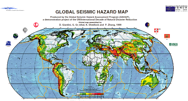
Although far from tectonic boundaries Australia is more seismically active than the interiors of other continental plates. Although these intra-plate earthquakes are less common than those that occur along plate boundaries, earthquakes with magnitude 7 or more can happen occasionally. Elsewhere in the world earthquakes of this magnitude, when they strike near major population centres, can cause significant damage and loss of life.
There are numerous faults throughout the urban area of Sydney. Although most of these show little sign of recent activity recurrence intervals on faults in Australia can measure in the order of tens to hundreds of thousands of years. At the foot of the Blue Mountains lies the 28 km long Kurrajong Fault Complex. This has been the subject of quite a bit of research as it could produce large earthquakes of magnitude 7 or greater. The likelihood of a large earthquake on this fault is highly uncertain, though it is probably smaller than 1 in 100,000 per year.
Built Environment
Sydney has a very low density. Of its 1.5 million dwellings 55% are separate houses and only 10% are in apartment buildings of 4 or more storeys. Some construction in the city survives from the early 1800s. Houses built prior to the 1930s are likely to be of poorer unreinforced masonry construction and more prone to structural damage or collapse in the event of an earthquake. Houses built since the 1980s should include modern seismic resistant elements based on the mapped hazard for Sydney at the time. Asbestos was a common construction material from 1945 to 1980 and could be disturbed by even light earthquake damage.
Sydney Airport handles 35.6 million passengers and 470,000 tonnes of cargo per year. In addition to the Airport a large amount of heavy industry is clustered around Botany Bay. This includes Port Botany, the Kurnell Refinery and Desalination Plant. All these assets are on unconsolidated or reclaimed land (notably the runways of Sydney airport) more likely to experience strong earthquake shaking.
The Earthquake Threat to Sydney

Site classes for parts of Sydney (values D, DE and E show weaker soils and thus greater amplification of earthquake shaking)
Sydney is located in a moderate earthquake hazard zone for the Australian continent. A peak ground acceleration of 0.05g has an annual exceedance probability of 1 in 500. The likelihood of of different peak ground accelerations being exceeded in the Sydney area is given in the table below. Earthquake shaking can be much worse in soft, sandy or watery soils – indeed it’s on these soils that damage is often most severe. The amplification of ground acceleration can be up to a facor of three. Although most of Sydney sits on relatively firm ground there are many areas on softer soils. The most important of these is Botany Basin, which extends north from Botany Bay almost as far as the Sydney CBD. The Botany Basin is a low-lying swampy area with a water table close to the surface. There are other smaller areas of unconsolidated sediments and fill, particularly along the foreshore of Sydney Harbour. These areas are likely to experience greater ground shaking in an earthquake than older areas which sit on consolidated rock.
| 1/500 AEP2 | 1/1000 AEP | 1/2500 AEP | |
| Peak Ground Acceleration (g) | 0.05 | 0.1 | 0.15 |
| MMI | VI | VII | VII |
| Peak Ground Acceleration with soil amplification (g) | 0.15 | 0.3 | 0.5 |
| MMI with soil amplification | VII | VIII | IX |
| Typical damage at higher MMI |
Slight damage and cracking in old buildings. Unsecured parapets, brick gables, unreinforced chimneys and tiles may fall. | Heavy damage to old poorly constructed buildings, some collapse. Some damage to reinforced masonry buildings. Houses not secured to foundations may move. | Many old buildings destroyed. Damage to reinforced masonry buildings some with partial collapse. Some damage to new structures. Houses shifted off foundations. Brick veneers fall. |
An earthquake on the Kurrajong fault complex could potentially produce even stronger shaking but is less likely.
Although these earthquakes are rare emergency planning should not be discounted. Emergency planning for flood and tsunami in NSW considers events this rare and rarer.
The combination of unconsolidated sediments and a high water table in the Botany Basin means that it may be susceptible to liquefaction. No investigations of this potential have been undertaken.
Impacts of a Sydney Earthquake
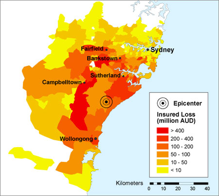
The threat of an earthquake in Sydney has received significant attention from the global reinsurance industry. In 2005 Munich Re included a Sydney earthquake as one of its top 10 scenarios for a 1000 year PML.3 Swiss Re considers an earthquake in Sydney to be one of its reference losses; an event with likelihood of 1/1,000 would have an economic loss of $20 billion.(18)
Other insurance risk modellers have prepared scenarios for an earthquake in the Sydney Basin. The one shown, estimates a loss of $11.3 billion for an earthquake of similar size to the Newcastle quake occurring 40 km south of Sydney.
A significant hazard is the collapse of unreinforced masonry awnings in older commercial districts. This was extensive in both the 1989 Newcastle and 2011 Christchurch earthquakes and led to fatalities. These awnings are prevalent in many commercial areas throughout Sydney.
Shaking amplified by local ground conditions and the possibility of liquefaction pose a potential hazard to the large industry around Botany Bay. Possible secondary impacts on travel and freight shipped through Sydney Airport and Port Botany could have flow-on economic effects to otherwise unaffected businesses. Damage to chemical plants or the Kurnell Oil refinery could lead to leaks, posing a risk to the surrounding population and having environmental impacts.
What could be done?
Research and Risk Assessment
Despite ongoing work in the Sydney Basin on earthquake hazards there is still substantial gaps in knowledge of the risk. Further research is required to address these knowledge gaps.
The seismology of possible earthquake producing faults is still not well understood. Further research on these sites would help define the probability of an earthquake occurring.
More crucial is a proper assessment of earthquake vulnerability, particularly in areas known to have a combination of old buildings and unconsolidated soils. The methodology developed by Geoscience Australia for a report on earthquake hazards in Newcastle and Lake Macquarie could be replicated across Sydney, with initial priority given to the following areas:
- The soft soils around Botany Bay
- Areas with high concentrations of old dwellings in the inner city
- Areas along Sydney harbour that have been reclaimed
Assessment of liquefaction potential in the Botany Basin and other similar areas should also be undertaken. Priority should be given to the areas that host key infrastructure, such as Sydney Airport.
A better understanding of the risk could help motivate governments to undertake mitigation and preparedness measures and prioritise areas for assessment.
Mitigation
Retrofitting of individual homes is likely to be expensive and not cost effective, however attention should be given to emergency infrastructure such as hospitals, important public buildings like schools and important heritage assets. City of Sydney Council has conducted seismic retrofitting of some of its town halls.
Special assessment should be made of masonry awnings in older commercial districts, particularly in areas where the ground conditions may lead to strong shaking. These proved to be particularly prone to collapse in the Newcastle earthquake.
Key industrial and aviation assets surrounding Botany Bay should be engaged to undertake detailed seismic risk assessments including addressing liquefaction. Retrofitting should be considered where indicated by these risk assessments. These facilities should also audit their business continuity and emergency plans to ensure minimal disruption to operations in the event of an earthquake.
Assessment of the seismic safety of bridges on Sydney’s extensive road and rail network should also be conducted.
Response Planning
The geology and urban geography of Sydney could create specific challenges for an earthquake response in Sydney. The low density of Sydney, potential for widespread shaking and areas likely to experience higher intensities due to local ground conditions will create widespread low-moderate damage with pockets of heavier damage. The low likelihood of an earthquake and lack of lived experience also pose challenges to community education and engagement. New South Wales may wish to develop a State Earthquake Emergency Sub-Plan similar to that used in Victoria. Alternatively Supporting Plans for key functions that may also be required in other disasters could be developed.
Key functions that will need to be addressed include Damage Assessment, Search and Rescue and Debris Management. Other elements of an earthquake response are already provided for in other emergency plans, however these should be reviewed to ensure that they would function appropriately in an earthquake emergency.
Damage Assessment
Damage assessment is required during the immediate response for activities like search and rescue and for the longer term recovery to determine whether buildings are safe to re-inhabit.
Use of new technologies could be used for rapid damage assessment. Creating social media and other technological solutions solely for earthquake is unlikely to be feasible, but the capacity to cope with reports of earthquake damage could be incorporated into other tools developed for hazards such as hailstorms.
Prioritising areas for longer term assessment could also be challenging, as will sourcing enough qualified engineers to conduct assessments. Rules of thumb for initial checks by unqualified personnel may need to be developed. This could identify buildings that need further inspection.
Search and Rescue
Although a substantial portion of Fire and Rescue NSW and the NSW State Emergency Service have search and rescue capabilities, including the rescue of people from collapsed and damaged structures there exists no plan for a large scale dispersed search and rescue operation.
Coordination and communication between the different rescue services will be critical to ensure that the worst affected areas receive the resources they need, yet are not overwhelmed with emergency services personnel.
Debris Management
Some areas will generate large amounts of debris as a result of destroyed structures and those needing to be demolished. Existing landfill sites are not likely to be adequate for the possibly large debris loads. This debris may also contain hazardous materials including asbestos. Careful management and disposal of this debris will be required to ensure that emergency service and waste management personnel and the broader community are not exposed.
1Local Magnitude, also known as Richter Magnitude.
2Annual Exceedance Probability: A measure of the chance per year of an event of that level or higher occurring.
3Probable Maximum Loss: A measure of the maximum loss in an insurance portfolio for a single event over a particular time period.
Tokyo Olympics – Will they be prepared?
The 2020 Olympics has been announced for Tokyo, one of the most earthquake prone megacities on the planet. The 2011 Sendai quake has also upped the chances of a big quake in the Tokyo area.
Despite extensive disaster preparedness for earthquakes Tokyo still has many vulnerabilities, and the clean-up of the Fukushima disaster will still be ongoing as the games get underway.
Plenty of Olympics have been held in disaster prone cities: Beijing, Athens, Los Angeles, Montreal, Mexico City and Rome all have high earthquake hazards, but fortunately a major natural disaster has not been visited on an Olympic Games. The 1908 games were originally going to be held in Rome, but were moved to London after the 1906 eruption of Mt Vesuvius led to financial pressures on the Italian Government. The worst olympics disaster in history was the terrorist attack on the 1972 Summer Games in Munich, and with billion dollar security budgets terrorism has been foremost in the minds of games’ organisers in recent years.
Although risk management has become a new priority for the IOC, assessment of disaster and emergency preparedness, particularly for natural disasters appears to be brief.
With the influx of athletes, officials and visitors Japan will need to put in place special measures to ensure that they are as prepared as the rest of the population, upgrade emergency response units and ensure that construction for the games is specially hardened – and that’s just for starters. A disaster ready games will be expensive and for a nation already faced with the recovery bill of the 2011 quake and tsunami and the clean-up of Fukushima it will be difficult for it to face up to the challenge. But the costs of not being prepared can be far greater.
L’Aquila Earthquake Verdict
 On the 6th of April 2009, a devastating earthquake struck the medieval Italian city of L’Aquila. In the town and others nearby 309 people were killed, more than 1,500 people injured, 20,000 buildings destroyed and 65,000 people left homeless.
In the wake of the earthquake 6 Italian scientists and one government official, members of the National Commission for Forecasting and Predicting Great Risks, were charged with manslaughter on the basis that they provided misleading and confusing information. Information that, prosecutors alleged, directly led to people deciding to remain in their homes after a minor earthquake which happened just hours before the fatal shock hit.
Just under three weeks ago the magistrate found all seven guilty prompting massive criticism from scientists worldwide.
Evidence based disaster management and the Triangle of Life
One of the big drawcards for me to disaster management is that it is such an interdisciplinary career. It brings together expertise in economics, geography, psychology, sociology, geophysics, meteorology, climate science, technology, business management, information technology, public policy, statistics, anthropology, gender and sexuality studies, culture and ethnography, engineering, environmental science, health, education, agriculture and more.
In a field that draws on so many areas of knowledge, research is critically important. This includes research that may not immediately be identified to have an emergency management impact.
As emergency management has so much knowledge to draw on I often ask myself why there isn’t a stronger engagement between practitioners and researchers in the field.
Conferences seem to be dominated by consultants and professional speakers (often those leaders who presided over emergency management disasters). Governments and NGOs in these times of austerity are cutting budgets and emergency management organisations aren’t immune. In any budget cuts, research is often the first to go.
Part of the problem is that large parts of academia, including many emergency management trade journals are walled off behind expensive paywalls. This problem is particularly acute for those working in developing countries who don’t have alternative means of access to this knowledge. Subsidised journals like the Australian Journal of Emergency Management are extremely important, as they enable any emergency manager to access high quality research and researchers to reach a broad emergency management audience.
Yet few publications see emergency management practitioners and researchers collaborating on papers, or indeed researching areas of interest to local practitioners.
The problem extends beyond that though. Emergency management lacks the culture of critical thinking common to the sciences. This tends to lead to an over-reliance on good ideas, historical practice and ‘common-sense’ which may in reality turn out to be ineffective or worse, actually harmful.
The Triangle of Life: Where’s the evidence?
In a place like Kathmandu earthquakes are never too far away as a discussion topic. In a couple of different conversations the ‘triangle of life’ idea has come up. This concept basically states that you should seek shelter next to heavy objects in an earthquake, as this will be where the survival spots are if the building collapses. I always thought that the concept had some utility in developing countries, without the enforcement of building codes in places like the US and Japan.
The concept first surfaced in an email chain letter (and continues to do the rounds, with elements of it popping up in this recent youtube video) authored by self-proclaimed rescue expert Doug Copp. The triangle of life idea has been thoroughly refuted by every government emergency management agency and experienced NGO I’ve been able to find. Some of the advice in the email is consistent with that of most earthquake preparedness experts, however most of it and especially the triangle of life are absolute nonsense. The credibility of the author is also highly questionable.
But what does the evidence say?
The Triangle of Life has an intrinsic appeal to some urban search and rescue practitioners who focus on rescuing people from collapsed structures. (On the other hand plenty have put together excellent rebuttals). However the people that these professionals rescue are not typical survivors. Most will either not be trapped or be rescued by other survivors using hands and basic tools.
By the time heavy Urban Search and Rescue teams arrive on the scene very few survivors will be found. Those that are found by these rescuers will be in voids within the collapsed structures – aka triangles of life.
This produces a sampling bias, the people in these voids are not representative of the total population of survivors.
The only experimental evidence for triangle of life came from an exercise in Turkey, which Copp was involved with (Unfortunately the links to all the primary source material on this exercise are broken). Dummies were placed within a structure, which was then collapsed. They found that the dummies placed in ‘duck, cover, hold’ positions were crushed and those placed in ‘triangle of life’ positions were not. Now by collapsed I mean demolished with conventional demolition techniques. Unfortunately this does not simulate how buildings fail in earthquakes, so little can be drawn from the results.
The other aspect of a controlled collapse is that the voids are much more predictable. Now I’m not suggesting that the ‘experimenters’ deliberately placed the dummies in these locations but subconsciously the experimenter effect could have come into play.
So the only piece of evidence for this advice is seriously flawed at best. The ‘triangle of life’ is already on shaky ground.
The other problem with this concept is that as an earthquake survival strategy the triangle of life will only protect you in the event of a building collapse. Odds are a total structural collapse will very likely ruin your day, despite what the theory claims. Any survival strategy will only increase your chances of survival, not guarantee it, in the event of a building collapse.
But what about if your building doesn’t collapse?
Most of the injuries (and some of the deaths) from an earthquake are caused by non-structural items such as bookcases, shelves, cabinets and the items on them. Many injuries are also caused by people fleeing (often without shoes) and cutting themselves on broken glass and other falling debris. This is precisely what the ‘duck, cover, hold’ strategy is aimed at avoiding.
For example in the 1994 Northridge Earthquake most fatalities were caused by building collapse, most injuries by falling over and being hit by falling objects. There were about 4 times more injuries than fatalities.
Researchers in Iran calculated that for a large earthquake there the number of people in areas exposed to falling debris (and not building collapse) would be 12,000 times the number of people exposed to building collapse. (Unfortunately this is the only scholarly article that I’ve found that directly compares ‘duck, cover, hold’ with ‘triangle of life’.)
So when the shaking starts, odds are that ‘duck, cover, hold’ will be the most appropriate strategy.
But what about community education? Could ‘triangle of life’ be explained too,allowing people to choose their own strategy?
Trying to communicate anything about earthquake preparedness is difficult enough. You could take a mixed strategy, that attempted to explain where the limited applicability of the triangle of life might be useful. However, this would only end up confusing most of the target audience, who may end up doing nothing or panicking. To reach the broadest audience any disaster preparedness message needs to be simple and the advice that will be applicable to the largest number of people is ‘duck, cover, hold’.
There’s no evidence to suggest that the triangle of life is any better than chance.
Which brings me back to my initial discussion:
Many career paths into disaster management don’t provide a strong background in research methods or critical thinking skills. When you combine this with the poor engagement between researchers and disaster managers and the difficulty in accessing scholarly publications its no wonder that rumours like the triangle of life to continue to circulate, even among disaster management professionals.
Research accessibility, critical thinking skills and cross sector engagement all need to be addressed to ensure disaster management is evidence based and thus successful.
