Home » Posts tagged 'research'
Tag Archives: research
Natural Disasters vs. Man-made Disasters – A Better Taxonomy?
We’re always bombarded with news about natural disasters, acts of god and stories of the wrath of mother nature. It’s a recurring meme in the public discussion about disasters and even amongst disaster management experts.
But we know that so called “natural disasters” aren’t really natural – disasters are a social phenomenon – they need something to impact on before . Even talking about natural and anthropogenic hazards doesn’t really work very well. Human practices around land-clearing and vegetation management have a significant influence on floods and bushfires. Landslides that impact on human development are very often due to modifications made to slopes. And before we started building fragile structures earthquakes would have been a curiosity like solar eclipses. Then there’s climate change – we’re beginning to drive change in the natural processes that govern many hazards.
Is there a better way for talking about hazards and disasters that goes beyond this false dichotomy?
One concept that I’ve been introduced to recently is the idea of policy domains and policy communities. A policy community is the group of all the participants in the policy making and implementation process for a particular subject. Some players are only concerned with one policy area (such as engineering seismologists) whilst others are concerned with many policy areas (such as meteorologists or disaster recovery experts).
To see how this concept could be used in categorising hazards I used Gephi to build a map of various hazards and how their policy communities are connected. For example blizzards and heatwaves are connected because they both relate to meteorology and climate – there’s overlap in their policy community. An engineer may work in both the earthquake policy community, the dam failure policy community and the structural collapse policy community and so on. This is a very subjective process, without data on how experts in various fields are connected (using say LinkedIn), this is really just built on what I think. But let’s see if we can pull some groups of hazards out of this map:

Click for a larger version.
Based on the connections between the different policy communities I’ve pulled out three separate broad policy domains:
Settlements – this comprises most of the traditional natural hazards policy domain, but adds in a few other engineering related hazards such as structural collapse (which has huge overlaps with policy domains like earthquake) and dam failure (which could almost be considered a sub-speciality of the flood policy domain). The drivers and mitigation options for these hazards relate to where and how we build our houses, neighbourhoods and cities.
Society – this comprises human health, human security and agricultural hazards. This is a pretty diverse set of hazards (as evidenced by their sparse connections) but they mostly relate to people and societies. It could be broken up a bit further, but for simplicity I’ve grouped them.
Economy – this group has industrial/technological accidents, transport accidents and utilities failures, there’s pretty big overlap with terrorism (which I placed in the societal group) and a number of the Settlements policy domains. Most of these hazards relate to economic activity in the modern age and comprise most of the traditional anthropogenic hazards policy domain. I think that labelling this group Economy is instructive as it reminds us that the so-called ‘human-caused’ disasters aren’t caused by people per se, but the productive activities we do and the materials and technologies used in them. It’s this group of hazards that have evolved the fastest and continue to evolve rapidly.
So let’s forget natural hazards and anthropogenic hazards – how about Settlement hazards, Societal hazards and Economic hazards?
Risky Links: Global Disaster Reports
In all my courses here in Pavia we’ve been getting into the alphabet soup of international disaster management. One thing that’s got me a little confused are all the international reports on disasters. So I’ve compiled a list of all the regular reports brought out in the international space on disasters and data and trends in their impact and response. One thing about most of these reports (particularly for a data geek like me) is that they’re underpinned by massive amounts of data on disasters, their impact and response – including time series.
Global Assessment of Risk – This report is published by the United Nations Office for Disaster Risk Reduction (UNISDR) every two years.
World Disasters Report – Published annually by the International Federation of Red Cross and Red Cresent Societies (IFRC).
World Risk Report – Published annually by the Institute for Environment and Human Security at the United Nations University (UNU-EHS)
Global Risks – Published annually by the World Economic Forum (WEF).
Annual Disaster Statistical Review – Published by the Centre for Research on the Epidemiology of Disasters (CRED), this data in this annual report is used in many other international reporting.
Sigma Natural Catastrophes and Man-Made Disasters – Swiss Re publishes this report annually as a special issue of it’s Sigma magazine.
Global Humanitarian Assistance Report – Published annually by Development Initiatives.
Humanitarian Accountability Report – Published annually by the Humanitarian Accountability Project
A Review of Natural Disasters – Published annually by the Brookings Institute
An Earthquake in Sydney: Could it happen here
 A few weeks ago a small earthquake shook areas of Sydney around Campbelltown. The tremor prompted an article in The Fifth Estate where experts warned that most people vastly underestimate the risks of an earthquake in Australia. Prior to this I had been researching the risk of an earthquake in Sydney as part of an assignment. I found that whilst the likelihood of a Sydney earthquake are small, the consequences could be great.
Earthquake Sources
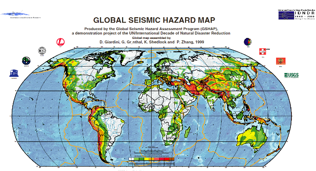
Although far from tectonic boundaries Australia is more seismically active than the interiors of other continental plates. Although these intra-plate earthquakes are less common than those that occur along plate boundaries, earthquakes with magnitude 7 or more can happen occasionally. Elsewhere in the world earthquakes of this magnitude, when they strike near major population centres, can cause significant damage and loss of life.
There are numerous faults throughout the urban area of Sydney. Although most of these show little sign of recent activity recurrence intervals on faults in Australia can measure in the order of tens to hundreds of thousands of years. At the foot of the Blue Mountains lies the 28 km long Kurrajong Fault Complex. This has been the subject of quite a bit of research as it could produce large earthquakes of magnitude 7 or greater. The likelihood of a large earthquake on this fault is highly uncertain, though it is probably smaller than 1 in 100,000 per year.
Built Environment
Sydney has a very low density. Of its 1.5 million dwellings 55% are separate houses and only 10% are in apartment buildings of 4 or more storeys. Some construction in the city survives from the early 1800s. Houses built prior to the 1930s are likely to be of poorer unreinforced masonry construction and more prone to structural damage or collapse in the event of an earthquake. Houses built since the 1980s should include modern seismic resistant elements based on the mapped hazard for Sydney at the time. Asbestos was a common construction material from 1945 to 1980 and could be disturbed by even light earthquake damage.
Sydney Airport handles 35.6 million passengers and 470,000 tonnes of cargo per year. In addition to the Airport a large amount of heavy industry is clustered around Botany Bay. This includes Port Botany, the Kurnell Refinery and Desalination Plant. All these assets are on unconsolidated or reclaimed land (notably the runways of Sydney airport) more likely to experience strong earthquake shaking.
The Earthquake Threat to Sydney

Site classes for parts of Sydney (values D, DE and E show weaker soils and thus greater amplification of earthquake shaking)
Sydney is located in a moderate earthquake hazard zone for the Australian continent. A peak ground acceleration of 0.05g has an annual exceedance probability of 1 in 500. The likelihood of of different peak ground accelerations being exceeded in the Sydney area is given in the table below. Earthquake shaking can be much worse in soft, sandy or watery soils – indeed it’s on these soils that damage is often most severe. The amplification of ground acceleration can be up to a facor of three. Although most of Sydney sits on relatively firm ground there are many areas on softer soils. The most important of these is Botany Basin, which extends north from Botany Bay almost as far as the Sydney CBD. The Botany Basin is a low-lying swampy area with a water table close to the surface. There are other smaller areas of unconsolidated sediments and fill, particularly along the foreshore of Sydney Harbour. These areas are likely to experience greater ground shaking in an earthquake than older areas which sit on consolidated rock.
| 1/500 AEP2 | 1/1000 AEP | 1/2500 AEP | |
| Peak Ground Acceleration (g) | 0.05 | 0.1 | 0.15 |
| MMI | VI | VII | VII |
| Peak Ground Acceleration with soil amplification (g) | 0.15 | 0.3 | 0.5 |
| MMI with soil amplification | VII | VIII | IX |
| Typical damage at higher MMI |
Slight damage and cracking in old buildings. Unsecured parapets, brick gables, unreinforced chimneys and tiles may fall. | Heavy damage to old poorly constructed buildings, some collapse. Some damage to reinforced masonry buildings. Houses not secured to foundations may move. | Many old buildings destroyed. Damage to reinforced masonry buildings some with partial collapse. Some damage to new structures. Houses shifted off foundations. Brick veneers fall. |
An earthquake on the Kurrajong fault complex could potentially produce even stronger shaking but is less likely.
Although these earthquakes are rare emergency planning should not be discounted. Emergency planning for flood and tsunami in NSW considers events this rare and rarer.
The combination of unconsolidated sediments and a high water table in the Botany Basin means that it may be susceptible to liquefaction. No investigations of this potential have been undertaken.
Impacts of a Sydney Earthquake
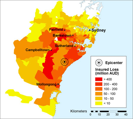
The threat of an earthquake in Sydney has received significant attention from the global reinsurance industry. In 2005 Munich Re included a Sydney earthquake as one of its top 10 scenarios for a 1000 year PML.3 Swiss Re considers an earthquake in Sydney to be one of its reference losses; an event with likelihood of 1/1,000 would have an economic loss of $20 billion.(18)
Other insurance risk modellers have prepared scenarios for an earthquake in the Sydney Basin. The one shown, estimates a loss of $11.3 billion for an earthquake of similar size to the Newcastle quake occurring 40 km south of Sydney.
A significant hazard is the collapse of unreinforced masonry awnings in older commercial districts. This was extensive in both the 1989 Newcastle and 2011 Christchurch earthquakes and led to fatalities. These awnings are prevalent in many commercial areas throughout Sydney.
Shaking amplified by local ground conditions and the possibility of liquefaction pose a potential hazard to the large industry around Botany Bay. Possible secondary impacts on travel and freight shipped through Sydney Airport and Port Botany could have flow-on economic effects to otherwise unaffected businesses. Damage to chemical plants or the Kurnell Oil refinery could lead to leaks, posing a risk to the surrounding population and having environmental impacts.
What could be done?
Research and Risk Assessment
Despite ongoing work in the Sydney Basin on earthquake hazards there is still substantial gaps in knowledge of the risk. Further research is required to address these knowledge gaps.
The seismology of possible earthquake producing faults is still not well understood. Further research on these sites would help define the probability of an earthquake occurring.
More crucial is a proper assessment of earthquake vulnerability, particularly in areas known to have a combination of old buildings and unconsolidated soils. The methodology developed by Geoscience Australia for a report on earthquake hazards in Newcastle and Lake Macquarie could be replicated across Sydney, with initial priority given to the following areas:
- The soft soils around Botany Bay
- Areas with high concentrations of old dwellings in the inner city
- Areas along Sydney harbour that have been reclaimed
Assessment of liquefaction potential in the Botany Basin and other similar areas should also be undertaken. Priority should be given to the areas that host key infrastructure, such as Sydney Airport.
A better understanding of the risk could help motivate governments to undertake mitigation and preparedness measures and prioritise areas for assessment.
Mitigation
Retrofitting of individual homes is likely to be expensive and not cost effective, however attention should be given to emergency infrastructure such as hospitals, important public buildings like schools and important heritage assets. City of Sydney Council has conducted seismic retrofitting of some of its town halls.
Special assessment should be made of masonry awnings in older commercial districts, particularly in areas where the ground conditions may lead to strong shaking. These proved to be particularly prone to collapse in the Newcastle earthquake.
Key industrial and aviation assets surrounding Botany Bay should be engaged to undertake detailed seismic risk assessments including addressing liquefaction. Retrofitting should be considered where indicated by these risk assessments. These facilities should also audit their business continuity and emergency plans to ensure minimal disruption to operations in the event of an earthquake.
Assessment of the seismic safety of bridges on Sydney’s extensive road and rail network should also be conducted.
Response Planning
The geology and urban geography of Sydney could create specific challenges for an earthquake response in Sydney. The low density of Sydney, potential for widespread shaking and areas likely to experience higher intensities due to local ground conditions will create widespread low-moderate damage with pockets of heavier damage. The low likelihood of an earthquake and lack of lived experience also pose challenges to community education and engagement. New South Wales may wish to develop a State Earthquake Emergency Sub-Plan similar to that used in Victoria. Alternatively Supporting Plans for key functions that may also be required in other disasters could be developed.
Key functions that will need to be addressed include Damage Assessment, Search and Rescue and Debris Management. Other elements of an earthquake response are already provided for in other emergency plans, however these should be reviewed to ensure that they would function appropriately in an earthquake emergency.
Damage Assessment
Damage assessment is required during the immediate response for activities like search and rescue and for the longer term recovery to determine whether buildings are safe to re-inhabit.
Use of new technologies could be used for rapid damage assessment. Creating social media and other technological solutions solely for earthquake is unlikely to be feasible, but the capacity to cope with reports of earthquake damage could be incorporated into other tools developed for hazards such as hailstorms.
Prioritising areas for longer term assessment could also be challenging, as will sourcing enough qualified engineers to conduct assessments. Rules of thumb for initial checks by unqualified personnel may need to be developed. This could identify buildings that need further inspection.
Search and Rescue
Although a substantial portion of Fire and Rescue NSW and the NSW State Emergency Service have search and rescue capabilities, including the rescue of people from collapsed and damaged structures there exists no plan for a large scale dispersed search and rescue operation.
Coordination and communication between the different rescue services will be critical to ensure that the worst affected areas receive the resources they need, yet are not overwhelmed with emergency services personnel.
Debris Management
Some areas will generate large amounts of debris as a result of destroyed structures and those needing to be demolished. Existing landfill sites are not likely to be adequate for the possibly large debris loads. This debris may also contain hazardous materials including asbestos. Careful management and disposal of this debris will be required to ensure that emergency service and waste management personnel and the broader community are not exposed.
1Local Magnitude, also known as Richter Magnitude.
2Annual Exceedance Probability: A measure of the chance per year of an event of that level or higher occurring.
3Probable Maximum Loss: A measure of the maximum loss in an insurance portfolio for a single event over a particular time period.
Risky Bites: Disaster Inquiry Keywords
I’ve been working on analysing recommendations from the list of disaster inquiries I’ve put together. At the moment I’ve come up with a list of keywords.
Here are the top 10 (note the analyser does it on a word root basis, so all plurals and forms are included):
- manage/management/manager
- fire
- emergency
- service
- government
- plan/planning
- develop/developing/development
- recommend/recommendation
- state
- ensure
Update on the Climate Change and Emergency Preparedness Senate Inquiry
Well it’s been two months since I posted my last update and the Climate Change and Emergency Preparedness Inquiry is in full swing. As I suspected the reporting date has been extended to the 26th of June (and even that date is still rather ambitious). There are now 338 submissions (most of the new ones being from individuals) and hearings have been held in Melbourne, Brisbane and Perth (the transcripts are available online). Hearings in Sydney and Canberra are scheduled for the next couple of days. I have only skimmed through the content of the hearings and there’s some interesting reading, but I’ll leave it to the inquiry to sum them up in its report.
Climate Change, Extreme Weather and Emergency Preparedness Senate Inquiry: Part 6
In this final instalment of my series on the Recent trends in and preparedness for extreme weather events Inquiry I’ll address the remaining terms of reference in a roundabout way. See Part 1, Part 2, Part 3, Part 4 and Part 5 here. The remaining terms deal with Australia’s overall response to climate change adaptation and national coordination of risk management. I want to address the impact of climate change on severe weather events being far from the only climate impact relevant to emergency management; climate change adaptation being far from the only emerging challenge in emergency management; and the interconnectedness of many current and emerging threats for Australia and the world.
(f) progress in developing effective national coordination of climate change response and risk management, including legislative and regulatory reform, standards and codes, taxation arrangements and economic instruments;
(g) any gaps in Australia’s Climate Change Adaptation Framework and the steps required for effective national coordination of climate change response and risk management; and
(h) any related matter.
Climate Change, Extreme Weather and Emergency Preparedness Senate Inquiry: Part 3
In the previous two posts I have examined current trends and future projections of climate change impacts on natural hazards, the estimated costs of extreme weather and potential insurance impacts. In this instalment I move onto the preparedness terms of reference:
(c) an assessment of the preparedness of key sectors for extreme weather events, including major infrastructure (electricity, water, transport, telecommunications), health, construction and property, and agriculture and forestry;
Fact: Disasters are political
On the eve of the US Presidential election it’s been barely a week since North America was impacted by one of the costliest disasters in US history. Although the mass media has largely moved on from the effects of the storm, its impact on the US Presidential election is likely to be debated for some time to come.
Before Hurricane Sandy even hit though there were the usual calls for the disaster not to be politicised. However endorsements for Obama’s handling of the response from Republican and Independent leaders, along with the crackpot right blaming gays and the Muslim Brotherhood and the green left blaming climate change quickly quashed those calls.
Fact is, disasters are political.
IDRC Davos 2012: Post Conference Reflections
During the final week of August 2012 I had the opportunity to attend and volunteer at the 4th International Disaster and Risk Conference in Davos, Switzerland. This report summarises the conference and my experiences there. At the end of the report are links to the conference program, papers and presentations which I would encourage the reader to peruse.
IDRC Davos 2012
Tomorrow I’m off to the International Disaster Risk Conference 2012 in Davos, Switzerland.
I’ll be volunteering there and checking out as much of the latest research and best practice in disaster risk management as I can. It’s particularly encouraging to see sessions on cascading mega disasters, urban risks, the future of risk management and broader governance approaches in a post-Hyogo Framework for Action environment.
I hope to post a couple of updates during the conference and a longer recap on my return to Kathmandu. In the meantime check out the conference website or follow them on twitter.
