Home » Articles posted by casuscalamitas (Page 2)
Author Archives: casuscalamitas
Risky Links: Global Disaster Reports
In all my courses here in Pavia we’ve been getting into the alphabet soup of international disaster management. One thing that’s got me a little confused are all the international reports on disasters. So I’ve compiled a list of all the regular reports brought out in the international space on disasters and data and trends in their impact and response. One thing about most of these reports (particularly for a data geek like me) is that they’re underpinned by massive amounts of data on disasters, their impact and response – including time series.
Global Assessment of Risk – This report is published by the United Nations Office for Disaster Risk Reduction (UNISDR) every two years.
World Disasters Report – Published annually by the International Federation of Red Cross and Red Cresent Societies (IFRC).
World Risk Report – Published annually by the Institute for Environment and Human Security at the United Nations University (UNU-EHS)
Global Risks – Published annually by the World Economic Forum (WEF).
Annual Disaster Statistical Review – Published by the Centre for Research on the Epidemiology of Disasters (CRED), this data in this annual report is used in many other international reporting.
Sigma Natural Catastrophes and Man-Made Disasters – Swiss Re publishes this report annually as a special issue of it’s Sigma magazine.
Global Humanitarian Assistance Report – Published annually by Development Initiatives.
Humanitarian Accountability Report – Published annually by the Humanitarian Accountability Project
A Review of Natural Disasters – Published annually by the Brookings Institute
Etymology of Disasters
One of my favourite pastimes is getting hung up over terminology used in disaster management – different jargon means different things in different places. This can be problematic. For example I recall one instance where some relative newcomers to emergency management in Australia were promoting the establishment of Local Resilience Forums in Australia. Thing is that Australia already has them – for example in NSW they’re called Local Emergency Management Committees and in Queensland Local Disaster Management Groups. Even simple words like risk and resilience can mean different things to different professionals – and that’s without even taking into account community understanding of various words.
I thought it might be interesting to look at where some of the common words we use come from so I did some poking around on an online etymology dictionary and here’s what I found:
| accident | Used in English from the late 1300s it is from 1100s old French from the Latin accidentem/accidere “to happen or fall out” from ad– and cadere “fall”. |
| alarm | First in use from early 1300s from old French alarme, from the Italian all’arme “to arms!” |
| alert | Used since the 1590s from the French alerte from the Italian all’erta “to the height” from erta “lookout, high tower” past participle of ergere “raise up” from the Latin erigere “raise”. |
| catastrophe | Although in use in English since the 1530s it originally meant a “reversal of what is expected” acquiring its present meaning around 1748. The word is from the Latin catastropha from the Greek katastrophe, from katastrephein literally meaning a down-turn. |
| command | In use since around 1400 from old French comand/comander from the vulgar Latin commandare from Latin commendare “to recommend, entrust to” |
| control | The present use as “to direct or dominate” is from the mid 1400s. From early 1300s “to check or regulate” from the Anglo-French contreroller “exert authority” from the medieval Latin contrarotulus “a counter or register” from Latin contra– (meaning against) and rotulus (meaning wheel). |
| coordination | Circa 1600 meaning “orderly combination” from the French coordination from late Latin coordinationem from Latin coordinare “to arrange or set in order” from com– (meaning “together”) and ordinatio “arrangement” from ordo “order”. Present meaning of “harmonious action” used since 1855. |
| disaster | From the 1590s derived from middle French désastre which is from the Italian disastro meaning “ill-starred”. |
| emergency | First used around the 1630s it is derived from the Latin emergens, present participle of emergere meaning “to rise up or bring forth”. |
| hazard | First used around 1300 (though the modern meaning only evolved around the 1540s) from the 12th century old French hazard which may be from the Spanish azar “an unfortunate card or throw at dice”. The Spanish word is possibly from the Arabic words az-zahr “the die” or yasara “he played dice”. |
| mitigation | From mid 1300s from the Latin mitigationem/mitigare “soften, make tender” from mitis “gentle, soft” and agere “do or make”. |
| peril | First used in English around 1200 it comes from the 10th century French word peril from the Latin periculum meaning “an attempt, trial, experiment; risk, danger” which comes from the Greek peria “trial, attempt, experience” |
| rescue | Used since around 1300 from the old French rescorre ”protect or keep safe” from re– and escourre “to cast off” which is from the Latin excutere “to shake off”. |
| resilience | Used since the 1620s it’s from the Latin resiliens/resilire meaning “to rebound/recoil” which is a combination or re– and salire “to jump/leap” (and interestingly where the word salient comes from). |
| risk | First recorded in English in 1728 it entered into usage in the 1660s from the French word risque which itself comes from the Italian risco (which is now rischio) from riscare meaning “run into danger”. |
| vulnerability | Vulnerable was first used around 1600 from the late Latin vulnerabilis which means “wounding”. |
| warning | Since the late 1300s from old French monition from Latin monitionem “warning or admonition” from monere “to warn”. |
An Earthquake in Sydney: Could it happen here
 A few weeks ago a small earthquake shook areas of Sydney around Campbelltown. The tremor prompted an article in The Fifth Estate where experts warned that most people vastly underestimate the risks of an earthquake in Australia. Prior to this I had been researching the risk of an earthquake in Sydney as part of an assignment. I found that whilst the likelihood of a Sydney earthquake are small, the consequences could be great.
Earthquake Sources
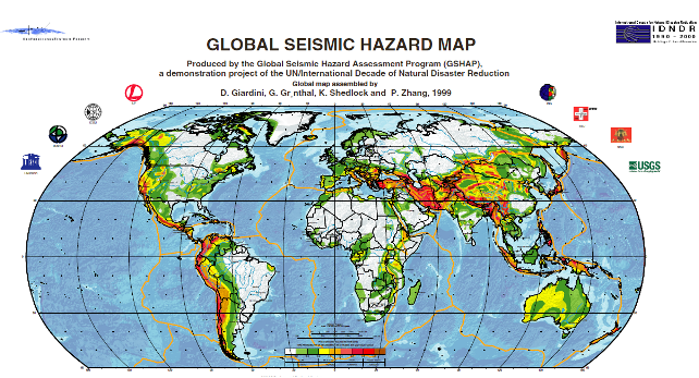
Although far from tectonic boundaries Australia is more seismically active than the interiors of other continental plates. Although these intra-plate earthquakes are less common than those that occur along plate boundaries, earthquakes with magnitude 7 or more can happen occasionally. Elsewhere in the world earthquakes of this magnitude, when they strike near major population centres, can cause significant damage and loss of life.
There are numerous faults throughout the urban area of Sydney. Although most of these show little sign of recent activity recurrence intervals on faults in Australia can measure in the order of tens to hundreds of thousands of years. At the foot of the Blue Mountains lies the 28 km long Kurrajong Fault Complex. This has been the subject of quite a bit of research as it could produce large earthquakes of magnitude 7 or greater. The likelihood of a large earthquake on this fault is highly uncertain, though it is probably smaller than 1 in 100,000 per year.
Built Environment
Sydney has a very low density. Of its 1.5 million dwellings 55% are separate houses and only 10% are in apartment buildings of 4 or more storeys. Some construction in the city survives from the early 1800s. Houses built prior to the 1930s are likely to be of poorer unreinforced masonry construction and more prone to structural damage or collapse in the event of an earthquake. Houses built since the 1980s should include modern seismic resistant elements based on the mapped hazard for Sydney at the time. Asbestos was a common construction material from 1945 to 1980 and could be disturbed by even light earthquake damage.
Sydney Airport handles 35.6 million passengers and 470,000 tonnes of cargo per year. In addition to the Airport a large amount of heavy industry is clustered around Botany Bay. This includes Port Botany, the Kurnell Refinery and Desalination Plant. All these assets are on unconsolidated or reclaimed land (notably the runways of Sydney airport) more likely to experience strong earthquake shaking.
The Earthquake Threat to Sydney

Site classes for parts of Sydney (values D, DE and E show weaker soils and thus greater amplification of earthquake shaking)
Sydney is located in a moderate earthquake hazard zone for the Australian continent. A peak ground acceleration of 0.05g has an annual exceedance probability of 1 in 500. The likelihood of of different peak ground accelerations being exceeded in the Sydney area is given in the table below. Earthquake shaking can be much worse in soft, sandy or watery soils – indeed it’s on these soils that damage is often most severe. The amplification of ground acceleration can be up to a facor of three. Although most of Sydney sits on relatively firm ground there are many areas on softer soils. The most important of these is Botany Basin, which extends north from Botany Bay almost as far as the Sydney CBD. The Botany Basin is a low-lying swampy area with a water table close to the surface. There are other smaller areas of unconsolidated sediments and fill, particularly along the foreshore of Sydney Harbour. These areas are likely to experience greater ground shaking in an earthquake than older areas which sit on consolidated rock.
| 1/500 AEP2 | 1/1000 AEP | 1/2500 AEP | |
| Peak Ground Acceleration (g) | 0.05 | 0.1 | 0.15 |
| MMI | VI | VII | VII |
| Peak Ground Acceleration with soil amplification (g) | 0.15 | 0.3 | 0.5 |
| MMI with soil amplification | VII | VIII | IX |
| Typical damage at higher MMI |
Slight damage and cracking in old buildings. Unsecured parapets, brick gables, unreinforced chimneys and tiles may fall. | Heavy damage to old poorly constructed buildings, some collapse. Some damage to reinforced masonry buildings. Houses not secured to foundations may move. | Many old buildings destroyed. Damage to reinforced masonry buildings some with partial collapse. Some damage to new structures. Houses shifted off foundations. Brick veneers fall. |
An earthquake on the Kurrajong fault complex could potentially produce even stronger shaking but is less likely.
Although these earthquakes are rare emergency planning should not be discounted. Emergency planning for flood and tsunami in NSW considers events this rare and rarer.
The combination of unconsolidated sediments and a high water table in the Botany Basin means that it may be susceptible to liquefaction. No investigations of this potential have been undertaken.
Impacts of a Sydney Earthquake
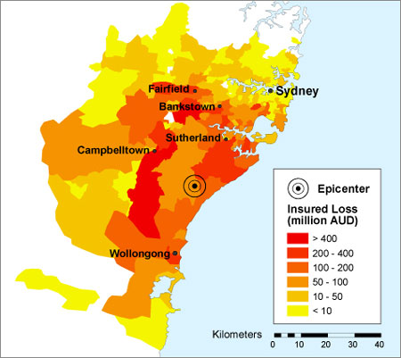
The threat of an earthquake in Sydney has received significant attention from the global reinsurance industry. In 2005 Munich Re included a Sydney earthquake as one of its top 10 scenarios for a 1000 year PML.3 Swiss Re considers an earthquake in Sydney to be one of its reference losses; an event with likelihood of 1/1,000 would have an economic loss of $20 billion.(18)
Other insurance risk modellers have prepared scenarios for an earthquake in the Sydney Basin. The one shown, estimates a loss of $11.3 billion for an earthquake of similar size to the Newcastle quake occurring 40 km south of Sydney.
A significant hazard is the collapse of unreinforced masonry awnings in older commercial districts. This was extensive in both the 1989 Newcastle and 2011 Christchurch earthquakes and led to fatalities. These awnings are prevalent in many commercial areas throughout Sydney.
Shaking amplified by local ground conditions and the possibility of liquefaction pose a potential hazard to the large industry around Botany Bay. Possible secondary impacts on travel and freight shipped through Sydney Airport and Port Botany could have flow-on economic effects to otherwise unaffected businesses. Damage to chemical plants or the Kurnell Oil refinery could lead to leaks, posing a risk to the surrounding population and having environmental impacts.
What could be done?
Research and Risk Assessment
Despite ongoing work in the Sydney Basin on earthquake hazards there is still substantial gaps in knowledge of the risk. Further research is required to address these knowledge gaps.
The seismology of possible earthquake producing faults is still not well understood. Further research on these sites would help define the probability of an earthquake occurring.
More crucial is a proper assessment of earthquake vulnerability, particularly in areas known to have a combination of old buildings and unconsolidated soils. The methodology developed by Geoscience Australia for a report on earthquake hazards in Newcastle and Lake Macquarie could be replicated across Sydney, with initial priority given to the following areas:
- The soft soils around Botany Bay
- Areas with high concentrations of old dwellings in the inner city
- Areas along Sydney harbour that have been reclaimed
Assessment of liquefaction potential in the Botany Basin and other similar areas should also be undertaken. Priority should be given to the areas that host key infrastructure, such as Sydney Airport.
A better understanding of the risk could help motivate governments to undertake mitigation and preparedness measures and prioritise areas for assessment.
Mitigation
Retrofitting of individual homes is likely to be expensive and not cost effective, however attention should be given to emergency infrastructure such as hospitals, important public buildings like schools and important heritage assets. City of Sydney Council has conducted seismic retrofitting of some of its town halls.
Special assessment should be made of masonry awnings in older commercial districts, particularly in areas where the ground conditions may lead to strong shaking. These proved to be particularly prone to collapse in the Newcastle earthquake.
Key industrial and aviation assets surrounding Botany Bay should be engaged to undertake detailed seismic risk assessments including addressing liquefaction. Retrofitting should be considered where indicated by these risk assessments. These facilities should also audit their business continuity and emergency plans to ensure minimal disruption to operations in the event of an earthquake.
Assessment of the seismic safety of bridges on Sydney’s extensive road and rail network should also be conducted.
Response Planning
The geology and urban geography of Sydney could create specific challenges for an earthquake response in Sydney. The low density of Sydney, potential for widespread shaking and areas likely to experience higher intensities due to local ground conditions will create widespread low-moderate damage with pockets of heavier damage. The low likelihood of an earthquake and lack of lived experience also pose challenges to community education and engagement. New South Wales may wish to develop a State Earthquake Emergency Sub-Plan similar to that used in Victoria. Alternatively Supporting Plans for key functions that may also be required in other disasters could be developed.
Key functions that will need to be addressed include Damage Assessment, Search and Rescue and Debris Management. Other elements of an earthquake response are already provided for in other emergency plans, however these should be reviewed to ensure that they would function appropriately in an earthquake emergency.
Damage Assessment
Damage assessment is required during the immediate response for activities like search and rescue and for the longer term recovery to determine whether buildings are safe to re-inhabit.
Use of new technologies could be used for rapid damage assessment. Creating social media and other technological solutions solely for earthquake is unlikely to be feasible, but the capacity to cope with reports of earthquake damage could be incorporated into other tools developed for hazards such as hailstorms.
Prioritising areas for longer term assessment could also be challenging, as will sourcing enough qualified engineers to conduct assessments. Rules of thumb for initial checks by unqualified personnel may need to be developed. This could identify buildings that need further inspection.
Search and Rescue
Although a substantial portion of Fire and Rescue NSW and the NSW State Emergency Service have search and rescue capabilities, including the rescue of people from collapsed and damaged structures there exists no plan for a large scale dispersed search and rescue operation.
Coordination and communication between the different rescue services will be critical to ensure that the worst affected areas receive the resources they need, yet are not overwhelmed with emergency services personnel.
Debris Management
Some areas will generate large amounts of debris as a result of destroyed structures and those needing to be demolished. Existing landfill sites are not likely to be adequate for the possibly large debris loads. This debris may also contain hazardous materials including asbestos. Careful management and disposal of this debris will be required to ensure that emergency service and waste management personnel and the broader community are not exposed.
1Local Magnitude, also known as Richter Magnitude.
2Annual Exceedance Probability: A measure of the chance per year of an event of that level or higher occurring.
3Probable Maximum Loss: A measure of the maximum loss in an insurance portfolio for a single event over a particular time period.
Risky Links: More Sydney Bushfires
The fires keep on coming and so does the coverage. Here’s more of the best commentary:
- Lateline: Fire expert, Professor David Bowman, discusses the latest bushfire emergency. Lateline (in fact the whole ABC) is doing some rather excellent coverage. Check it out.
- The Conversation: Fire and climate change: don’t expect a smooth ride
- The Conversation: Living with fire: deciding where to build
- Australian Financial Review: Controlled burns to manage bushfires won’t work: expert
- Sydney Morning Herald: NSW Fires: If You Live in the Bush, build for the Bush
- Sydney Morning Herald: Waiting for the Fires Reveals What’s Really Important
- Sydney Morning Herald: In the land of bushfires we need a national plan
State of Emergency – What powers does it add?
For the second time in 18 months NSW is under a State of Emergency due to a natural disaster. You can read the wording of the declaration here.
From memory, before the flooding in 2012 there have only been two declarations of a State of Emergency in NSW under the current legislation.
- 1998 – After the Longford Gas explosion in Victoria to cut off supplies in NSW border areas that were supplied from Victoria.
- 1991 – During a Blue Green Algae outbreak in the Darling River to put the Public Works Department in charge of the government response.
A State of Emergency is declared under the State Emergency and Rescue Management Act to give emergency services extraordinary powers to combat an emergency situation. These powers are usually more extensive than those available to the emergency services under their own acts (in this case the Rural Fires Act).
I thought it might be interesting to do a play by play comparison of the powers under each act. This is necessarily a simplification, if you’re interested or need to use this stuff you need to read each Act, their Regulations or even get legal advice.
A few quick notes. Not all RFS Members are Officers for the purposes of the Act. I’m not sure which rank confers these powers or whether they’re delegated in another fashion, but if anyone knows I’d appreciate it. An Emergency Services Officer for the purposes of the SERM Act include RFS members of or above the position of Deputy Captain.
Coordination and Direction
Under the RFS Act
Who Exercises it?: The Commissioner of the RFS (s44)
What is it’s extent? When a Section 44 bushfire emergency is declared the Commissioner or delegate (in reality, the incident management teams) take control of the bushfire response. Directions can be issued to the RFS, Fire and Rescue NSW, the NSW Police Force and other persons in connection with fire fighting operations. (s45)
Under the SERM Act
Who Exercises it?: The Minister
What is it’s extent? The Minister gains the ability to direct the entire resources of government in the emergency response – even if those directions are contrary to other legislation or law (with the exception of the Essential Services Act). (s36)
Comments
In my opinion this is one of the most important provisions of the State of Emergency powers – Michael Eburn covers it in his excellent post on the State of Emergency declaration here.
Evacuation
Under the RFS Act
Who Exercises it? RFS Officers
What is it’s extent? Only if a person, vehicle or thing is interfering with RFS Operations. (s22A)
Under the SERM Act
Who Exercises it?: Emergency Services Officers where authorised by the Minister
What is it’s extent? Evacuate and remain out of the emergency area, these powers include the use of force. (s37)
Comments
The RFS does not have any power to evacuate people for their safety, so if they believe it is necessary They could rely on common law powers of the Police to detain and remove people from an area for their own safety, but a State of Emergency is likely to produce much greater levels of compliance and require less use of force. However this does raise the question of whether the RFS should have the power under their own act to ‘force’ evacuations. The traditional paradigm in community response to fires has been to leave it up to the community to decide. Recently we’ve seen a trend towards strongly advising people to evacuate in the worst fires – and an overall preference to evacuation as the safest measure. The State Emergency Service has significant evacuation powers under their Act in the case of flood emergencies, which can even include the use of force. To give the RFS greater powers to evacuate people would give them more options in the event of a fire without needing to resort to a State of Emergency.
Entry
Under the RFS Act
Who Exercises it? RFS Officers in the possession of a written authority (s32) and in some circumstances providing notice (s29)
What is it’s extent? Any premises to exercise their functions. (s23)
Under the SERM Act
Who Exercises it?: Any person in possession of a written authority (s37F) and in some circumstances providing notice (s37C)
What is it’s extent? To comply with a direction to undertake safety measures in section 37.
Road Closure
Under the RFS Act
Who Exercises it? Officers in charge of RFS brigades
What is it’s extent? Any road in the vicinity of a fire (and the RFS do not need to be controlling that closure – they can instruct somebody else to do so) (s24)
Under the SERM Act
Who Exercises it?: Emergency Services Officers where authorised by the Minister
What is it’s extent? Any road in an emergency area (and the emergency services officer does not need to ‘man’ the closure) (s37A)
Pulling down buildings and other safety measures
Under the RFS Act
Who Exercises it? RFS Officers
What is it’s extent? To protect life and property destroy buildings, fences, vegetation or establish fire breaks (and the RFS can instruct somebody else to do so) (s25)
Under the SERM Act
Who Exercises it?: Emergency Services Officers where authorised by the Minister can direct actions to
What is it’s extent? Pulling down or destroying damaged walls or premises. The destruction or removal of any material or thing that threatens life or property or inhibits the emergency response. (s37A)
Use of Force
Under the RFS Act
Who Exercises it? RFS Officers where authorised by the Commissioner
What is it’s extent? Only for the purpose of gaining entry (s31)
Under the SERM Act
Who Exercises it?: Persons where authorised by the Minister.
What is it’s extent? Only for the purpose of gaining entry (s37E)
Commandeering Property
Under the RFS Act
Who Exercises it? RFS Officers
What is it’s extent? Take and use without payment any water on any land. (s26)
Under the SERM Act
Who Exercises it?: The Minister
What is it’s extent? Take possession of and use any property. The property owner may receive but is not entitled to compensation.
Disconnection of Utilities
Under the RFS Act
None.
Under the SERM Act
Who Exercises it?: Emergency Services Officers where authorised by the Minister can direct actions to
What is it’s extent? Shutting off of any main supply of gas, water or other substance or gas or electricity to premises in the emergency area. (s37A)
Protection from Liability
Under the RFS Act
Who Exercises it? Any officer or member of the RFS, other fire fighting agencies or those acting under their direction
What is it’s extent? Protected persons (or the Crown) cannot be held liable for actions done in good faith.
Under the SERM Act
Who Exercises it?: Any person acting under the execution of a State of Emergency.
What is it’s extent? Protected persons (or the Crown) cannot have legal proceedings brought against them for actions done in good faith.
Worst Case Scenario: Evacuation of the Blue Mountains
The NSW Government has declared a State of Emergency with regard to the bushfires in the Blue Mountains and the forecast deteriorating weather conditions. One of the reasons given for the declaration is the additional evacuation powers this grants the Rural Fire Service (once the actual wording of the declaration is published I’ll be making a post on what exactly are the additional powers it grants). Large areas of the Blue Mountains could come under threat. Though the likelihood of a complete evacuation of the Blue Mountains has been played down the RFS says that it is looking at the planning.
So let’s look at the feasibility of a large scale evacuation. I’ll use a back-of-the-envelope version of the evacuation timeline method developed by the NSW SES.
NSW does have a plan for a large scale evacuation – in the event of an extreme flood in the Hawkesbury-Nepean River (incidentally this plan also calls for the declaration of a State of Emergency – primarily to convey the seriousness of the situation). If there was to be a whole-scale evacuation of the Blue Mountains I would expect some elements of the evacuation planning around a Hawkesbury-Nepean flood to be utilised.
But is an evacuation even possible. Everyone would need to exit via the Great Western Highway, presumably to Sydney
Though the Great Western Highway is mostly double lane, dual carriageway it narrows to a single lane each way in a number of places, notably at Hazelbrook and Woodford. Single traffic lanes can carry 1200-1500 vehicles per hour. Standard practice is to halve this figure to account for emergency conditions, smoke, emergency vehicles, accidents etc. Census figures estimate a total of about 50,000 vehicles owned by households in the Blue Mountains area – experience shows that households will use all available vehicles to evacuate.
The math is pretty simple:
50,000 vehicles / 600 vehicles per hour = 83 hours or about 3.5 days. If Wednesday were indeed going to be catastrophic the evacuation would need to start now.
Even with perfect traffic conditions, contra-flow arrangements (which I highly doubt would be used as they would prevent emergency vehicles from coming in) and only 1 car per household it would still take a long time:
33,000 vehicles / 2400 vehicles per hour = 14 hours
What about trains?
Seated capacity of 6 car V set trains (those normally run on the Blue Mountains Line) is 608. At the peak they run at four trains per hour. Assuming double capacity and an increase to 6 trains per hour you have the ability to move about 7300 people per hour. The census gives a population of 75,000 for the blue mountains. So by train:
75,000 people / 7300 people per hour by train = 10 hours
Now if you could convince a whole lot of households to leave their cars at home, travel with only what they could carry (both of these are pretty unlikely assumptions) and take the train it might be possible to evacuate all the Blue Mountains in about 6 or 7 hours. Still too long?
If it did come to it, an evacuation of the Blue Mountains would be a multi-day round-the-clock operation involving massive coordination of transport assets, traffic control and a huge effort to convince the community of the need to leave very early. It would need to be called long before the fire was directly threatening properties – in the worst case the decision would need to be happening now.
Risky Links: NSW Bushfires
I was going to write a post on the Bushfires in NSW, links to climate change and the media discussion after Adam Bandt’s comments (though I do wish to point out the irony that many of those criticising Bandt’s timing are more than happy to blame the fires on Green ideas about land clearing) but others have said it better than I. Here’s a wrap of some of the best coverage to date on the fires:
David Holmes in the Conversation looks at the media discussion of the bushfires and climate change. Despite calls not to ‘politicise’ research shows that now is the best time to talk about extreme weather and climate change. Also read Adam Bandt’s article that started it in The Guardian.
In the Guardian Josh Taylor outlines the benefits of social media in keeping tabs on what’s happening, but that it has its drawbacks too.
Although the fire season is likely to lengthen in the future detecting historical changes in seasonality is difficult as David Bowman examines in Crikey.
Also in The Conversation Ross Bradstock looks at the reasons why the Blue Mountains is so vulnerable to bushfires and Janet Stanley covers climate change, arson and land use as three areas that need a greater focus on prevention.
The Australian argues that despite losses and the early arrival of the bushfire season we are getting better at Bushfire Management. Technology is improving how fires are fought as detailed in the Daily Telegraph but models are far from reliable, as pointed out by David Bowman in the Conversation.
NSW Bushfire History
Well it’s a smokey morning in Sydney, thousands of firefighters are still working hard and about a hundred fires are still burning with many out of control. I’ve been following the news here in Italy.
If indeed hundreds of homes have been lost, this could very well be the most damaging fires in the state’s history and I would expect there to be strong pressure for the Government to establish some sort of inquiry. So I’ve pulled together some information on past fires in NSW and some of the inquiries that they triggered. The data is taken from the COAG Bushfire Inquiry, a few RFS publications, the Insurance Council’s disaster statistics and my own lists of disaster inquiries.
In terms of property loss and insured loss the worst bushfire disaster in the State’s history was the 1993-94 fires that destroyed 206 homes. These fires killed four people and led to three separate inquiries. Since then there have been ten separate audits, inquiries and reviews into bushfires in NSW. There’s also been numerous federal inquiries and in other jurisdictions which have driven policy change in NSW. The most deadly bushfire in NSW’s history was the 1968-69 fires which killed 14 people and also destroyed 161 homes. I hope all the lessons we’ve learned through these fires and inquiries will not lead to a toll that high.
And the Australian fire season still has a long way to go. Click here to look at the full table as a google spreadsheet.
Other Bushfire related inquiries
1996 – Audit of New South Wales Fire Brigades : fire prevention
1998 – Audit of The Coordination of Bushfire Fighting Activities
2000 – Parliamentary Inquiry into the NSW Rural Fire Service
2001 – Follow up of Performance Audits: Coordination of bushfire fighting activities
2003 – Coronial Inquiry into the Circumstances of the Fire(s) in the Brindabella Range in January 2003
2004 – Parliamentary Inquiry into Fire Services Funding
2005 – Statutory Review of the Rural Fires Act 1997
2009 – Review of Bushfire Arson Laws
Risky Links: IDDR 2013
Today is International Day for Disaster Reduction, check out the website here and be sure to look at the results from the IDDR survey which looks at the contributions and needs of people with disabilities in disaster risk reduction. Their number one priority? Information.
Meanwhile in India Super cyclonic storm Phailin: the strongest cyclone ever in the North Indian Ocean Basin, made landfall yesterday – this piece in The Conversation gives some background. Check out the Hindustan Times for ongoing coverage.
And unseasonably hot weather in Australia has sparked a string of damaging bushfires predictably leading to calls for greater prescribed burning. However, planned burning is not necessarily as effective as many think. The design of bushfire mitigation activities needs to take science into account. These fires come as research to be published in Nature on Monday suggest the El Nino Southern Oscillation cycle will strengthen as a result of climate change, intensifying drought and bushfire risk. Even more concerning is new research showing that more than two-thirds of people would adopt a ‘wait and see’ approach when deciding to evacuate or defend in the face of a bushfire. Less than 1% would leave their homes on days of catastrophic or extreme fire danger – the safest option.
Risky Links
- Smartphone-powered earthquake detectors could help direct first responders in an emergency – One of the principal challenges of early response to an earthquake is rapid damage assessment. Currently seismologists use accelerometers, computer models and ‘did you feel it‘ websites to understand shaking intensity which feeds in to models like PAGER to estimate impact. Scientists here in Italy have published a new study proposing that the accelerometers in smartphones and tablets could be used to get a more accurate map of earthquake intensities and damage.
- The WDR 2014 and its Relevance for Disaster Risk Management – The World Bank’s GFDRR takes a look at the World Bank’s 2014 World Development Report titled “Risk and Opportunity: Managing Risk for Development”. This is the latest in a string of reports increasing the focus on risk management within development. The 2014 GDR argues that improved risk management can better protect development outcomes and create new opportunities to eradicate poverty. This is an important report in the lead up to the post 2015 development agenda which I expect to have a much greater focus on disaster reduction and risk management than the 2000 Millennium Development Goals.
- Video games and law of war – In this post the ICRC argues for greater implementation of the laws of war in realistic war simulation games (like Call of Duty, Medal of Honor and America’s Army). They note that they are working with some video game developers to implement this.
- Fukushima’s Worst-Case Scenarios – In this lengthy piece on slate.com the worst-case scenarios developed by scientists in the US and Japan during the early days of the Fukushima disaster are put under the microscope. Unsurprisingly the media’s treatment of these scenarios at the time didn’t accurately communicate them.
